
11-24-13 to 11-26-13
After 4 exams in 10 days I had a bit of a break for Thanksgiving so I headed out to hike the Benton Mackaye Trail between Noland Creek(The Road to Nowhere) and Smokemont Campground in Smoky Mountain National Park. This was my 2nd section of the BMT, it’s about 26 miles with 5500 feet of elevation gain. The forecast called for lows in the teens and highs in the 30s and 40s with a good chance of freezing rain on Tuesday. I finally got my base pack weight down to 20 lbs for this trip.
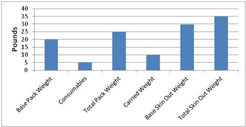
Weight Breakdown for the Trip
My wife dropped me off at the Noland Creek Trailhead on Sunday just before dark and I hiked about a mile to Campsite #65. This is a pretty nice site with 3 picnic tables and several fire rings. It was almost dark when I got there so I set up my tent and went to bed.

Campsite #65
The temperatures got down to about 15 degrees during the night. The nights are about 14 hours long during this time of the year, so I got up before sunrise to make breakfast and get ready to go. It was defenitly cold once I got out of my sleeping bag. At one point I poured water in my cook pot to wash it and it started to freeze within a few minutes. I started hiking along the Noland Creek Trail and warmed up once I got moving. The trail followed Noland Creek for about 7 miles.

One of many bridged crossings of Noland Creek
Most of the crossings were bridged, but there were two places where a ford would have been necessary if the water had been higher. We have had very little rain for the last month so the river was quite low. I was able to find other ways across both fords without too much difficulty.
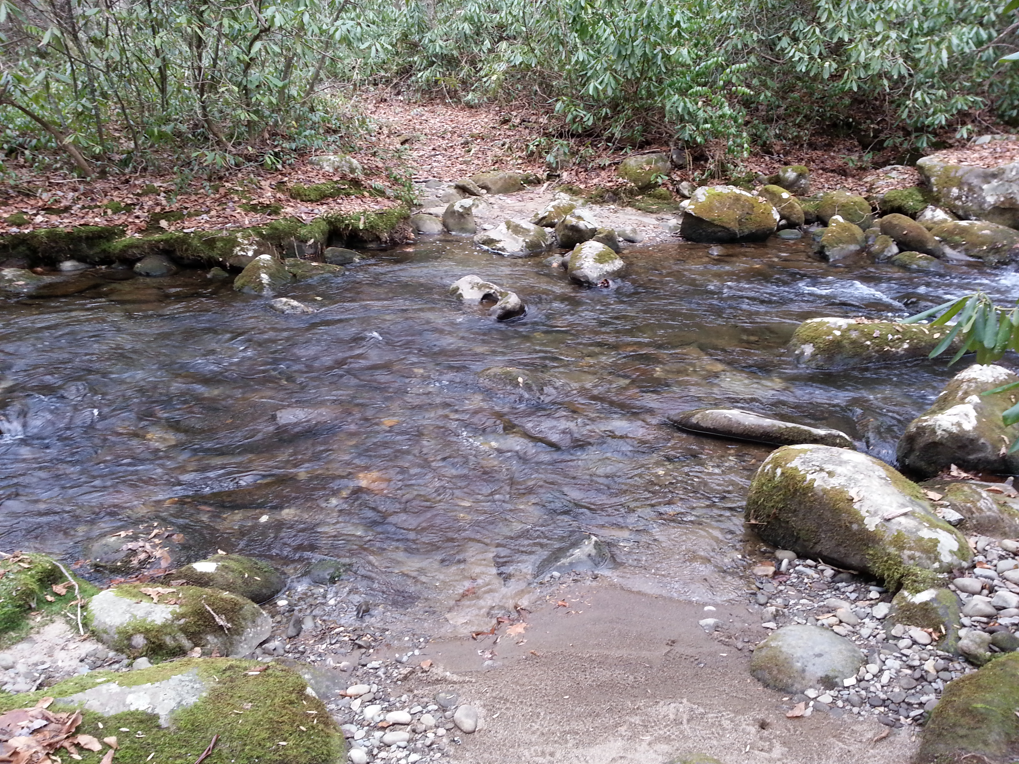
Ford of Noland Creek
After campsite #61 the trail climbs steeply for about a mile to Upper Sassafras Gap. There is a four way intersection at the top. The Benton Mackaye Trail follows the Pole Road Creek Trail down to the Deep Creek drainage area.

Upper Sassafras Gap
It had been quite cold all day, but once I reached the top of the gap and crossed over into the Deep Creek drainage it was much warmer and there was no wind. It was very strange because the elevation, terrain, and foliage of the two drainages are the same, but weather conditions were very different. I followed the Pole Road Creek Trail down towards Deep Creek. The trail crosses the creek about a dozen times with no bridges, but most of the crossings are relatively easy.

The Pole Road Creek Trail
After about 3 miles the trail met up with the Deep Creek Trail and I walked about half a mile downstream to Campsite #56. There are two parts to this campsite, one by the river and one near the trail. I set up right next to the river. I knew it was going to rain hard that night, but I didn’t see any evidence that the river ever floods the campsite. After building a fire and cooking dinner I sat up for a while after dark listening to the creek.

Campsite #56
I went to bed and around 8:00pm the freezing rain/hail started and coated the ground with ice. For the next 18 hours there was a steady downpour. At some point during the night it got warmer and the precipitation switched over to rain but I stayed dry in my tent. In the morning I got up, packed my gear inside the tent into a trash bag and then packed my tent and food into the top of the backpack. I put on a poncho and started the 13 mile hike out. Unfortunately I didn’t get any pictures during the last day because my camera is not waterproof.
I climbed about two miles on the Martin’s Gap Trail to the top of the Martin’s Gap and then took the Sunkota Ridge Trail to Newton Bald. When you’re hiking in a downpour for many hours there is no way that I have found to stay dry. All you can do is make sure you have enough insulation and keep moving to stay warm. Temperatures were in the 30s and 40s for most of the day so staying warm while being soaked was a priority. I started to get cold around Newton Bald when the elevation was over 5000 feet, but I quickly descended 3000 feet over the last five miles on the Newton Bald trail and my extremities warmed up.
My wife picked me up at Smokemont Campground at 4:30pm. I ended up hiking the last 13 miles in about 5.5 hours. The conditions weren’t great, but I didn’t see a single person on the whole trip and I definitely gained some good experience and insights into how my body handles hiking in cold wet weather. It’s definitely easier and more enjoyable to hike in zero degree weather rather than 40 degree weather when there is precipitation. I guess that is just the reality of backpacking in the Southern Appalachians during winter, but it definitely makes me miss the colder temperatures of the Rockies and Cascades.
